

Trasy 21 km a 51 km vedú rozmanitým terénom s dominantným podielom lesných úsekov.
Približne 80 % trasy tvorí prírodný povrch, zvyšok dopĺňajú spevnené a asfaltové úseky.
Beží sa najmä po turistických a cyklistických chodníkoch, ktoré ponúkajú autentický trailový zážitok v prostredí Zobora.
Trasa bude vyznačená vlastným značením – šípkami a fáborkami, aby ste sa mohli sústrediť na svoj výkon.
Pre maximálny komfort odporúčame mať trasu uloženú aj vo vlastnom zariadení –
stiahni si GPX súbor do hodiniek alebo mobilu a maj orientáciu vždy pod kontrolou.
Využiť môžeš aj turistické mapy alebo aplikáciu Mapy.com
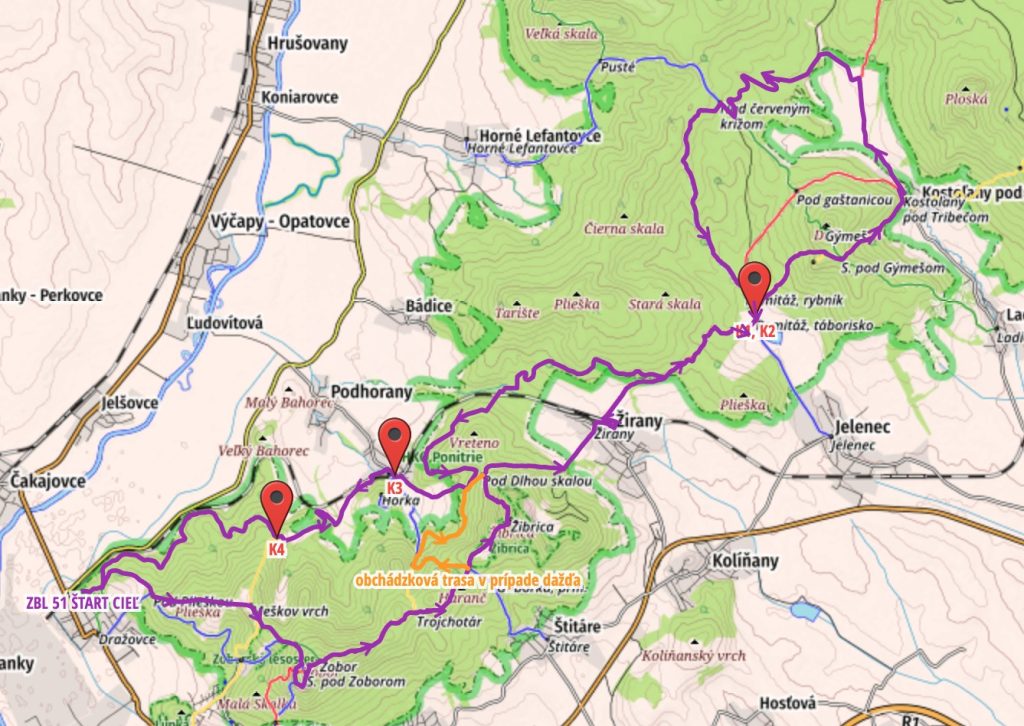
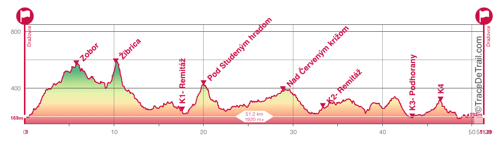
Route schedule:
Distance: 51 km, Climb: 1695 m, Descent: 1695 m
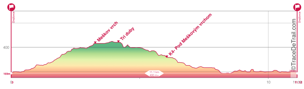
Church of St. Michael (Dražovský kostolík) - along the green tourist – Barohati – Plaska – Meshkov hill – Three oaks – Ski meadow – turn onto the blue tourist – turn intoright to the Zobor Hradisko nature trail – to to the Pyramid – Pyramid – Saddle under Zobor – Zobor – Trochanter – Saddle under Žibrica – Under Žibrica – turn left (not to Žibrica!) - Under the long rock – Zirany – direction Remitáž, campsite (K1) – saddle under Gýmesh – Kostoľany pod Tribečom – Jedlina mining plant (tourist red/ cycling (C)) – Above the Red Cross 800m (C) 3km (C) Briefly (C) – Remitage campsite (K2) – back to Žirany at 31km turn right (own sign). At 38 km you cross the railway line. Then up through the forest, then turn right 2800m (C) – odboč doprava na turistickú žltú – Podhorany Mechenice (K3) – pod Meškovým vrchom (K4) – odboč doprava (C), smer Dražovský kostolík – Barohati – Kostol sv. Michala (Dražovský kostolík)
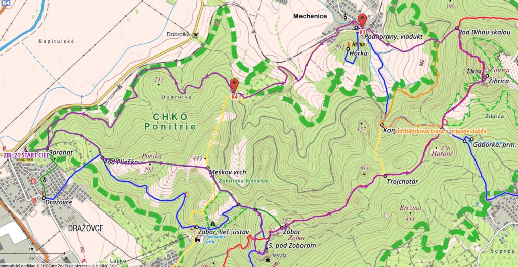
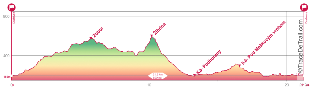
Route schedule:
Distance: 21,1 km, Climb: 856 m, Descent: 856 m
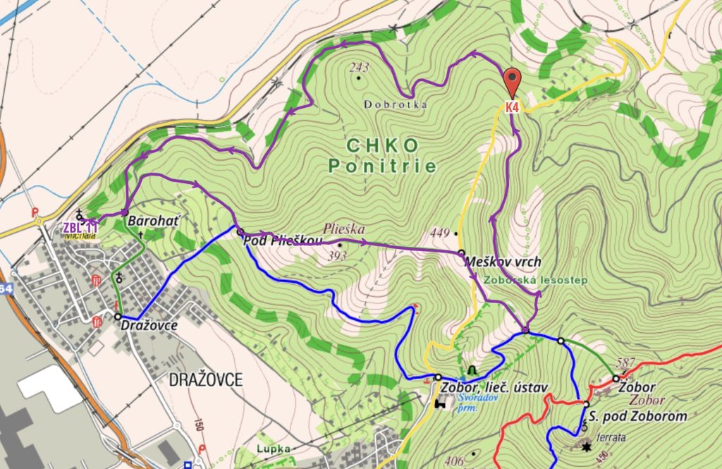
Kostol sv. Michala (Dražovský kostolík) – po zelenej turistickej značke – Barohati – Plaska – Meshkov hill – Three oaks – Ski meadow – odboč na modrú turistickú – odboč doprava na náučný chodník Zoborské hradisko – až na Pyramídu – Pyramid – Saddle under Zobor – Zobor – Trochanter – Saddle under Žibrica – Under Žibrica – odboč doľava (nie na Žibricu!) – Under the long rock – Podhorany Mechenice (K3)– pod Meškovým vrchom (K4)– odboč doprava (C) smer Dražovský kostolík – Barohati – odboč na turistickú zelenú – Kostol sv. Michala (Dražovský kostolík)
Route schedule:
Distance: 11 km, Climb: 377 m, Descent: 377 m
Kostol sv. Michala (Dražovský kostolík) – along the green tourist – Barohati – Plaska – Meshkov hill – Three oaks -Doľava zbeh na (C) – Pod Meškovým vrchom (K4) – Barohať – Kostol sv. Michala (Dražovský kostolík)
| Cookie | Duration | Description |
|---|---|---|
| cookielawinfo-checkbox-analytics | 11 months | This cookie is set by GDPR Cookie Consent plugin. The cookie is used to store the user consent for the cookies in the category "Analytics". |
| cookielawinfo-checkbox-functional | 11 months | The cookie is set by GDPR cookie consent to record the user consent for the cookies in the category "Functional". |
| cookielawinfo-checkbox-necessary | 11 months | This cookie is set by GDPR Cookie Consent plugin. The cookies is used to store the user consent for the cookies in the category "Necessary". |
| cookielawinfo-checkbox-others | 11 months | This cookie is set by GDPR Cookie Consent plugin. The cookie is used to store the user consent for the cookies in the category "Other. |
| cookielawinfo-checkbox-performance | 11 months | This cookie is set by GDPR Cookie Consent plugin. The cookie is used to store the user consent for the cookies in the category "Performance". |
| viewed_cookie_policy | 11 months | The cookie is set by the GDPR Cookie Consent plugin and is used to store whether or not user has consented to the use of cookies. It does not store any personal data. |